I have received some questions about the current volcano activity on the Big Island expressing concern for my property, so, here is some information.
This is from a news article from the Associated Press on March 25, 2025.
Lava began bubbling out of Hawaii’s most active volcano once again on Tuesday as Kilauea’s sporadic eruption resumed.
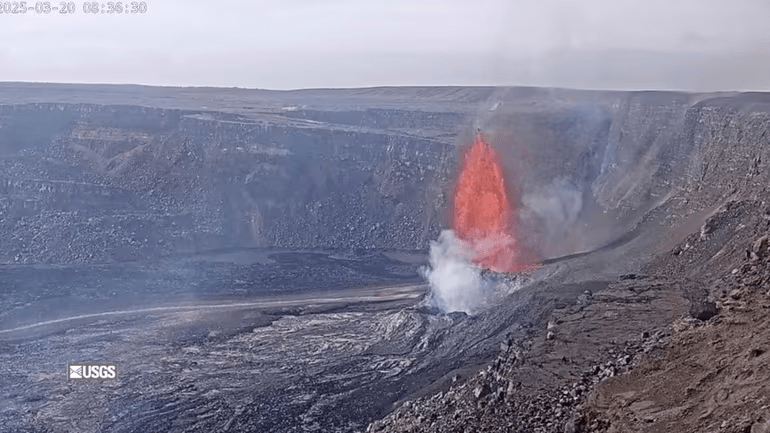
The eruption restarted at midday when molten rock began pouring out of a vent in Kilauea’s summit caldera, the Hawaiian Volcano Observatory said in a statement. The lava was contained within the caldera inside Hawaii Volcanoes National Park and wasn’t affecting any residential areas.
The volcano on the Big Island of Hawaii has been erupting on-and-off since Dec. 23. It’s shot tall fountains of lava high into the air and spilled molten rock across the caldera floor each time it’s come back to life. The spectacle is a popular attraction for tourists.
The current episode is the 15th of the current eruption. The shortest of the previous episodes lasted 13 hours while the longest went on for eight days. Pauses in between episodes have ranged between 24 hours to 12 days.
Kilauea is one of six active volcanoes in Hawaii, including one that is submerged underwater. The largest is Mauna Loa, which is also on the Big Island and which erupted in 2022. – end of qute from website.
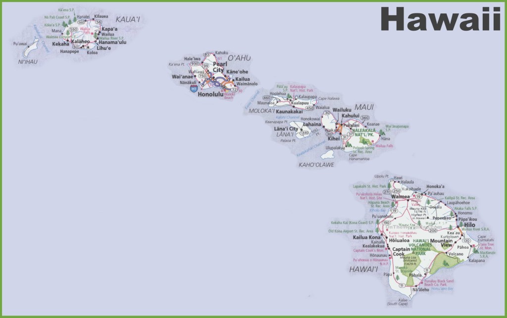
As a refresher, the map above shows where the Volcano National Park is located. If you look closely, you will see the town of Na’aleu down near the southern end of the western portion which is over Mauna Loa. While the entire island is just one lava flow on top of another, and on top of another, etc., the area of the National Park only encompasses about 20% of the island, and the caldera is maybe 1% of the park,, Of course, we all know that 1% can shut down the economy of the entire world, but that is a different subject!

This is an enlarged map of the National Park on the Big Island – the areas within the green lines. The park does not encompass the entirety of either Kilauea, nor Mauna Loa, but it does include the most active areas of these two volcanoes.
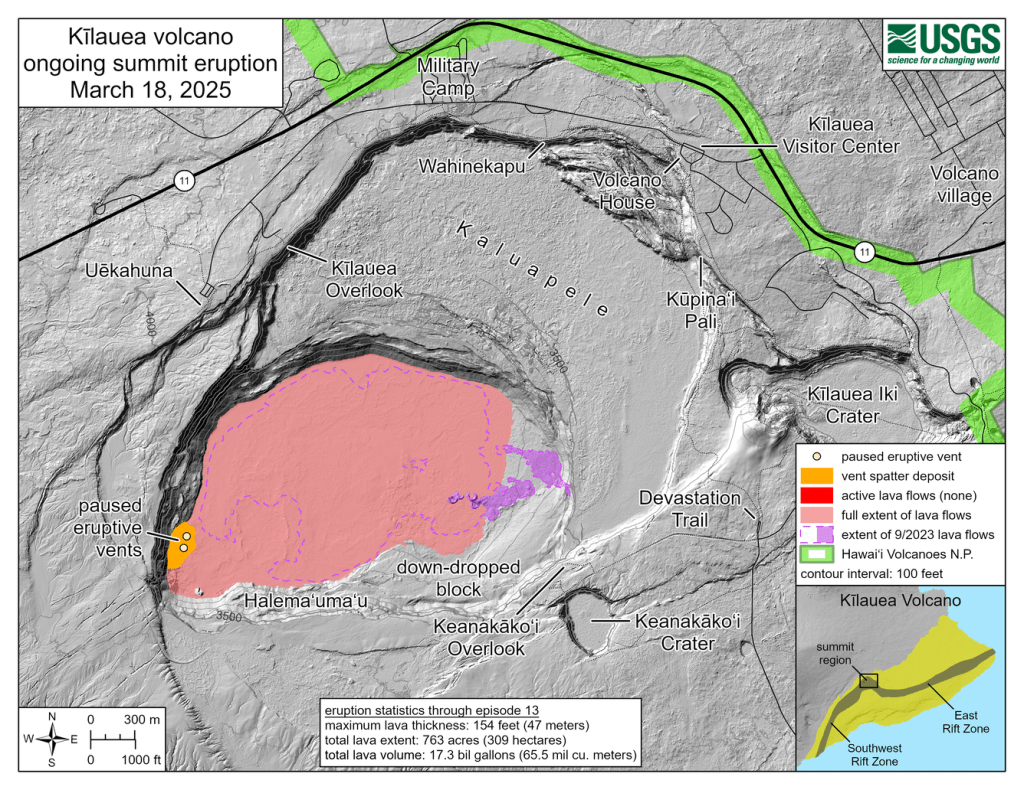
This map above shows the caldera of Kilauea within the National Park, with the current lava flow area shown in pink, and the eruptive vents on the south wall shown in yellow.
The island of Hawai’i is divided into lava zones.
More info from the USGS (United States Geological Society)

USGS Lava Hazard Zone definitions
The lava flow hazard zones are based on location of eruptive vents, past lava coverage, and topography.
- Zone 1 – Includes summits and rift zones of Kilauea and Mauna Loa volcanoes, where vents have been repeatedly active in historical time.
- Zone 2 – Areas adjacent to and downslope of zone 1. 15-25% of zone 2 has been covered by lava since 1800, and 25-75% has been covered within the past 750 years. Relative hazard within zone 2 decreases gradually as one moves away from zone 1.
- Zone 3 – Areas less hazardous than zone 2 because of greater distance from recently active vents and (or) because of topography. 1-5% of zone 3 has been covered since 1800, and 15-75% has been covered within the past 750 years.
- Zone 4 – Includes all of Hualalai, where the frequency of eruptions is lower than that for Kilauea or Mauna Loa. Lava coverage is proportionally smaller, about 5% since 1800, and less than 15% within the past 750 years.
- Zone 5 – Area on Kilauea currently protected by topography
- Zone 6 – Two areas on Mauna Loa, both protected by topography
- Zone 7 – Younger part of Mauna Kea volcano. 20% of this area was covered by lava in the past 10,000 years.
- Zone 8 – Remaining part of Mauna Kea. Only a few percents of this area has been covered by lava in the past 10,000 years.
- Zone 9 – Kohala Volcano, which last erupted over 60,000 years ago.
VOG
This is from the USGS website:
Best known for its spectacular lava fountains and flows, Kilauea also emits about 2,000 tons of irritating sulfur dioxide gas (SO2) gas each day during periods of sustained eruption. . . The word “vog,” an abbreviation for volcanic smog, was coined to identify this form of air pollution, which unfortunately has become a part of everyday life for people in Hawai`i.
Vog is created when SO2 and other volcanic gases combine and interact chemically in the atmosphere with oxygen, moisture, dust, and sunlight over periods of minutes to days. Vog is a visible haze consisting of gas plus a suspended mixture of tiny liquid and solid particles, called aerosol. The aerosol in vog is composed primarily of sulfuric acid and other sulfate compounds. Small amounts of several toxic metals, including selenium, mercury, arsenic, and iridium, have also been found in the volcanic air pollution coming from Kilauea. Far away from the volcano, such as along the Kona coast on the Island of Hawaii’s west side, aerosol particles dominate vog, but near Kilauea SO2 gas is a major component of vog. – end of quote from website –
YIKES!!!!
Trade Winds on Hawai’i
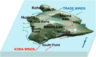
The trade winds on Hawai’i come from the northeast, and flow across the island to the west coast. These are met by the Kona Winds coming from the south. The confluence of these two wind patterns in the area of my property, pushes the VOG emitted from Kilauea up the slope of Mauna Loa and over to the other side, where it falls downslope towards Kailua-Kona. Most of the negative effects from the VOG affect the residents on the west coast in ways that we escape.
In conclusion
So, when people express concern over my owning property on an active volcano, I point out that this activity is (currently) contained within the caldera (the volcano’s crater)of the volcano. And while the fountains reach heights of 600 to 700 feet high, they are still not above the lip of this crater! Of course, this was not the case with the town of Kapalana that was covered by 80 feet of molten lava in 1986,

or the homes, and farms in Leilani Estates destroyed by over 30 feet of lava in 2018, times when Kilauea erupted outside the caldera.

However, both of these areas were within lava zone 2, and my property is in lava zone 6, an area that is shielded from possible lava flow by the surrounding topography. In 2022, Mauna Loa erupted at the peak, and due to the topography of the mountain, it flowed to the north. Should Mauna Loa ever erupt on the south facing slope, all bets are off for my property, and I would expect that in the matter of a few hours, my property will be inundated!
And as for the air polution caused by the volcano,

– in spite of everything from the “climate change” alarmists (gasoline powered leaf blowers are more damaging than volcanos), volcanoes do in fact change the climate of the entire world! – we are in a location that again, due to the topography, spares us from the negative effects of the VOG.
Like everything in life, there is always a risk. And what it boils down to is, just how much risk are you willing to accept?
TTFN
