This post is long overdue. Here is your geography lesson for today.
It is easy to assume that everyone knows where the Hawaiian Islands are located. They have been described as the most remote island chain in the world, located 2,390 miles (3,850 km) from California and 3,850 miles (6,195 km) from Japan. But just in case, I thought I should show this map:

Most people are familiar with the eight main islands – Oahu, where Honolulu, Waikiki, Diamond Head, and Pearl Harbor are located is the best known and called The Gathering Place.
Maui is perhaps the island where most people think of going for a vacation and is called the Valley Isle. The road to Hana is located on the island of Maui.
Kaua’i is known as the Garden Isle and is where many movies such as Jurassic Park, and Seven Days, Seven Nights, were made. Waimea Canyon, also known as the Grand Canyon of the Pacific, is located on Kaua’i ;
The big island (also known as Hawai’i) is just as it is called, the largest of them all, and the youngest – where the most current volcanic activity is taking place;
Niihau is totally privately owned and visitors are highly restricted. This island is known as the Forbidden Isle.
Molokai is mainly rural and agrarian, and the location for colonies for the treatment of people with leprosy were sent in the 1800’s.
Kahoolawe is also restricted to visitors, is uninhabited and is known as the Target Isle as it was used by the US Navy during WWII and up until 1990 for gunnery practice.
Lana’i is 98 % privately owned by Larry Ellison founder of Oracle corporation (as of about 2012). Until about ten years ago, 75% of the world’s pineapple came from Lana’i – that’s why it is known as the Pineapple Island.

What many people do not know, is that there are nine other islands – mainly atolls , sea mounts, pinnacles and islets – that make up the Northwestern Hawaiian Islands. In 1909, President Theodore Roosevelt had designated the area as a bird sanctuary and in 2000 President Bill Clinton designated it as an “ecosystem reserve”. On June 15, 2006, American President George W. Bush issued a public proclamation creating Papahānaumokuākea Marine National Monument under the Antiquities Act of 1906. (https://en.wikipedia.org/wiki/Northwestern_Hawaiian_Islands) President Obama increased the area to about four times the original size of 139,000 square miles of open ocean, containing a total of 3.1074 square miles of land area. Access to these islands is extremely limited and controlled to preserve the unique wildlife found in and around these islands.

Even though Midway is located among these isles, it is not part of Hawaii, but is a territory in itself and is part of the United States Minor Outlying Islands.
All total, there are 137 islands in the Hawaiian island chain. The total area within the area of Hawaii is so large that if the big island were located in New Orleans, the opposite end at Kure Atoll would be somewhere near San Francisco. . . with most of that open ocean.
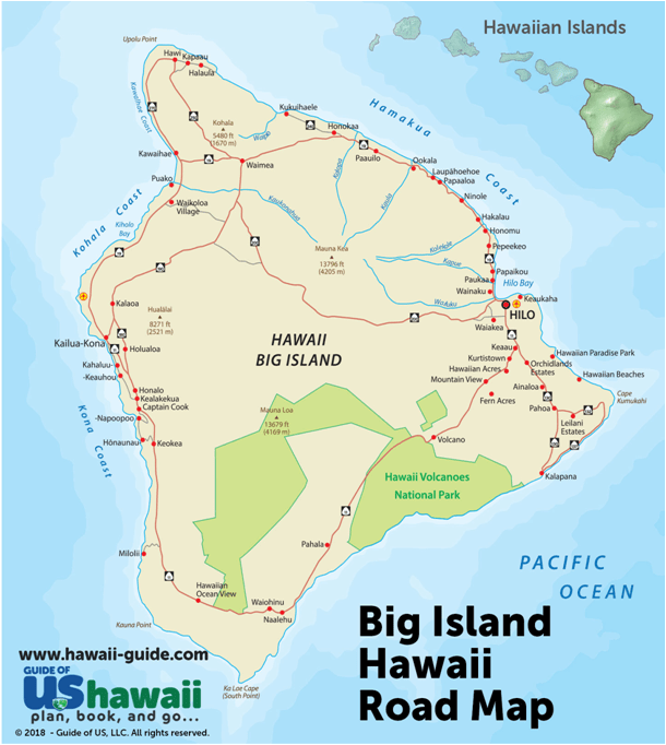
The big island of Hawai’i contains the bulk of the land area in Hawaii. In fact, all of the other 7 major islands could fit within the Big Island. The major cities are Kona on the west side where the climate is fairly dry, and Hilo on the east or windward coast that recieves the majority of the rain. King Kamehameha I was born and lived on the northern portion of this island. Our property is located near the southern point of the island known as South Point, or Ka Lae.
The majority of the following information comes from this website: https://www.lovebigisland.com/hawaii-blog/hawaii-volcano-history/
There are six volcanoes that combined to form the island of Hawai’i. A seventh is working on joining them soon – For a volcano, 10,00 years in the future is soon. The study of volcanoes (Volcanology – not to be confused with Vulcanology – the study of the planet Vulcan) leaves me with many questions. For example, I’m not really sure what makes each volcano a seperate volcano, and why all the volcanoes on Hawai’i are not just one big volcano with multiple outlets. Also, the method of measuring is a mystery to me. How do the scientists decide what is to be included as part of the volcano?
This seventh volcano is called Loihi. Currently, Loihi is located about 22 miles south of the big island. It last erupted in 1996 and is slowly building its way to the surface of the ocean.. scientists estimate that sometime in the next 10,000 to 100,000 years, it will break the surface of the ocean and become an actual island. Loihi and Kilauea combine to create a lot of seismic activity in the southern portion of the island of Hawai’i. Each week there are dozens of small earthquakes that are centered on an area about 15 miles to the northeast of our property. By small, most of these earthquakes measure around 2.2 on the richter scale. A few weeks ago, there was one measuring 4.3.
Kilauea is among the most active volcanoes on the earth, and has been currently erupting since 1952 with 36 different seperate eruptions in that time period. The latest started on December 20, 2020 and is still eruptng as of this writing. Kilauea is the youngest volcano with over 90% of its surface being less than 1,000 years old. The eruption in 2018 that destroyed over 700 homes also created over a square mile of new land at the southeast corner of the island.
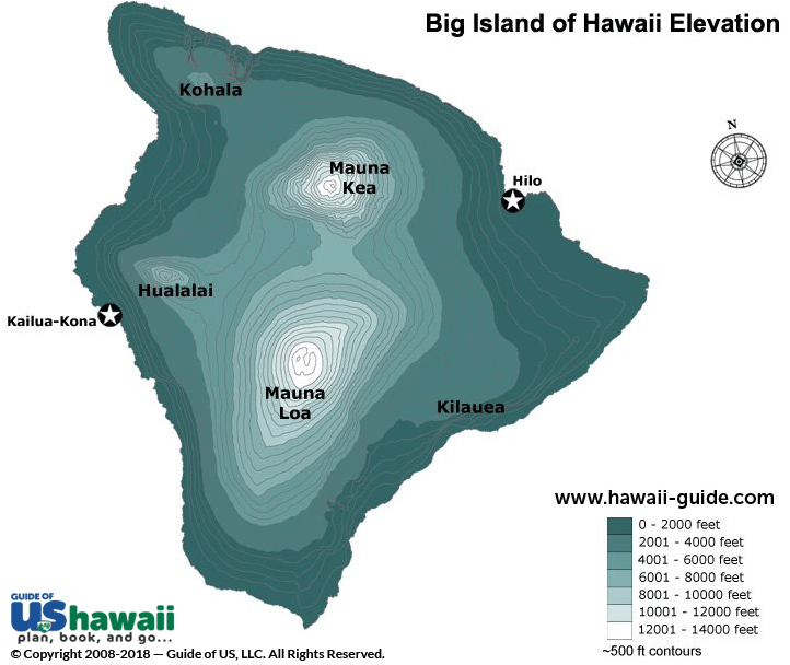
Mauna Kea is the tallest one at 33,000 feet tall – measured from its base – and the peak is around 13,796 feet above the ocean. At the top is one of the best observatories in the world. Mauna Kea is listed as a dormant volcano as the last time it erupted was 4600 years ago. Just yesterday in the life of a volcano.
Hualalai is the one to the east of Kona. Or rather, Kona is built on the west slope of Hualalai. While Hualalai is listed as an active volcano, it last erupted in 1801. In 1929 there were a series of seismic activities (earthquakes) that caused some damage, but no there was no lava flow. The fertile slopes of Hualalai make it perfect for growing coffee. While there are hiking trails on Hualalai, the best ones are on the upper slopes that is all privately owned and you need permission to be there – in other words, you need to pay a local tour guide.
Kohala is located on the northern portion of the Big island and is the oldest on the island at about 1 million years old. It last erupted over 120,000 years go, and is listed as being extinct. The Waipi’o valley is located as part of the Kohala Volcano. Portions of Kohala have been sliding off into the ocean for the last 100,000 years.
The next volcano is one that not many people will recognize. Mahukona was the initial volcano that started the building of the island of Hawai’i. It is located off the northwest coast of hawaii and the top is about 900 feet below sea level having never reached the surface of the ocean. It last erupted some 350,000 years ago and is also listed as being extinct.
Mauna Loa is the volcano on whose southern slope, my property is located. Mauna Loa is called the largest active volcano on the planet. It covers more than half the island of Hawai’i and extends 3 miles under the surface of the ocean. Mauna Loa has two main rift zones, or areas where the lava has flowed most recently. One is to the northeast, and the other is to the southwest. During two most recent eruptions of Mauna Loa in 1935 and 1984, lava has been flowing towards Hilo in the east. In 1935, the US Air Force tried diverting the lava flow by dropping bombs in its path – to no avail. The weight of Mauna Loa has caused the earth’s crust to be depressed over 8 kilometers, and Mauna Loa rises some 56,000 feet from its base. Listed as an active volcano, there is current activity both seismic as well as lava flow activity at the summit of Mauna Loa and an eruption is expected. But no one knows just when. Just a few weeks ago, there were a few earthquakes at the summit measuring over 3.0 as the lava is building up just under the summit.
Currently, there is debate that the volcano that is below the Gardner Seamounts in the Northwest Hawaiian Islands is twice the size of Mauna Loa. This volcano is called PŪHĀHONU. And no, . . .this volcano is not on the island of Hawai’i. . . just interesting info about whether or not Mauna Loa is truly the largest in the world.
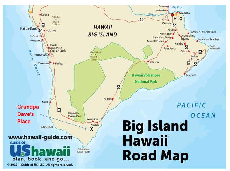
This is a road map of the lower portion of the big island showing Naalehu and South Point, and their relation to the locations of Hilo and Kona.
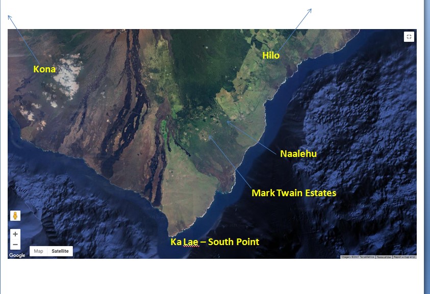
The satellite photo above shows the southern point of the Big Island with the town of Naalehu and the Mark Twain Estates.
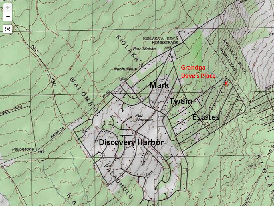
This topographic map shows the location of my property at about 1000 feet above sea level.
TTFN
